Authors: Apoorva Dewan, Ojasvi Bansal, Raman Kumar, and Aaditeshwar Seth
Ecological restoration is a complex process that requires a deep understanding of local landscapes, community needs, and environmental dynamics. Traditionally, identifying prospective restoration sites has relied on expert-defined rules—based on parameters such as land use, rainfall, elevation, or vegetation type, or on change detection from historical satellite maps.
While valuable, these top-down approaches often struggle with contextual variability. Restoration logic that works in one eco-region may not hold in another, as ecological and social factors vary dramatically across locations. What’s needed is a method that is local, adaptive, and accessible, and allows practitioners and communities themselves to define what restoration suitability means in their specific context.
That’s where the CoRE Stack Ecological Restoration Toolkit comes in.
A New Way of Thinking:
Instead of starting with fixed, expert-defined rules, our toolkit enables users to start with an example site – a place where restoration is ongoing or considered successful – and then discover other sites that are ecologically and socially similar.
This example-driven, bottom-up approach empowers local actors to define what “restorable” means for their region. Users can explore how a reference site performs across various environmental dimensions, then derive a customized set of parameters that best capture restoration potential elsewhere.
How It Works
We have integrated multiple geospatial datasets into the CoRE Stack platform, including:
- Rainfall
- Elevation and terrain
- Fire occurrences
- Land degradation
- Low biomass (wasteland) areas
- Change detection maps
- Land use and land cover (LULC)
Using these datasets, users can:
- Choose a reference site where restoration is happening or planned.
- Explore its characteristics like rainfall, elevation, vegetation mix, etc. by overlaying relevant data layers.
- Define parameter ranges around these observed values.
- Identify similar sites that fall within those ranges.
- Interactively refine parameters until the selection aligns with local knowledge.
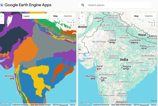
The toolkit visually supports this workflow through two synchronized maps:
- The left map allows users to experiment with and build rules.
- The right map applies these rules across regions to identify new potential restoration sites.
A control panel guides users step by step through this process.
See It in Action
Explore the Rule-Building Application
This demo video shows how users to experiment with the toolkit – building and adjusting rules based on reference sites.
Explore the Ready-rules Application
In this version, rules have been built for a few pilot sites (validation in progress). Users can explore how various geospatial layers combine to define and visualize similar restoration zones. You can watch the demo here.
Please refer to this thesis for the overall methodology. Special acknowledgements to Kiran Baldwin, Anand Kumar, Shashank Bhardwaj, Paul Blanchflower, and Madhura Niphadkar for many helpful joint working sessions to refine the system.
Get Involved
We invite practitioners, researchers, and organizations engaged in restoration or sustainable land management to explore the toolkit and share feedback.
If you’d like to collaborate or contribute datasets and insights: Write to us at contact@core-stack.org
Together, we can make ecological restoration more data-informed, participatory, and locally grounded, one landscape at a time.