Update, Oct 2026: The service is now available live via the CoRE Stack Tower Services. You can use the Continuous Ecological Monitoring (CEM) app to define spots and routes, upload regular updates and audio recordings, and trigger an analysis. For data and analysis you want to make public, you can trigger an upload-and-analyze to the tower service. See the live site and listen to bird sounds from Sanjav Van in Delhi.
———————————-
Field data collection sounds simple in theory: go out, observe things, record what you find. In practice, it quickly turns into dozens of audio files, scattered notes, random GPS logs, and a vague memory of “somewhere near that big tree.” We learned this the hard way while working on a bird audio collection project. The work was fun, the data management was not.
We wanted a tool that made fieldwork more efficient and less error-prone. Something that keeps the spatial context intact, helps you stay organized, and doesn’t require complicated GIS workflows just to view where a recording was taken. And while we were at it, why not also let researchers keep their data on their own machine, back it up on their own terms, and only share it when they are ready? That is where this toolkit began.
What we built
This is a data collection system designed for ecological monitoring, or any field project where location matters. It aims to sit right between simple GPS loggers and full-blown GIS software. It runs in your browser, so you just open the app, sign in, and start, and you can use it on your phone while you are out in the field.
You can:
- Define one or more study projects, each with its own site anywhere in the world.
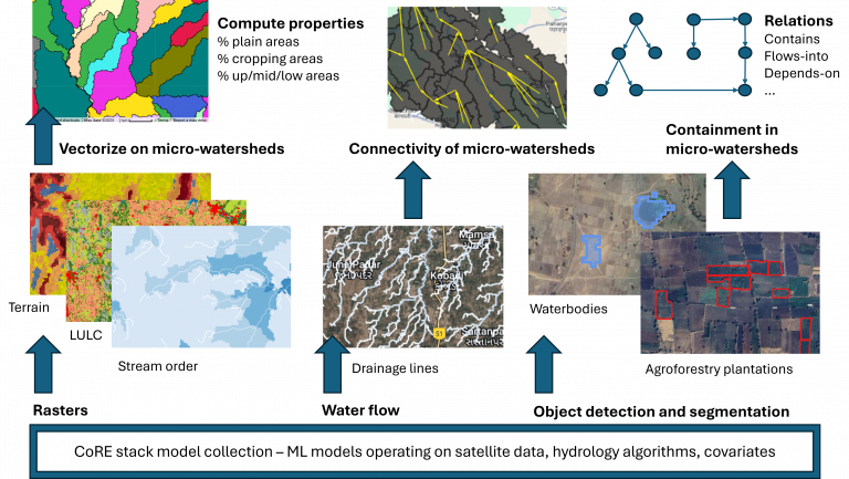
- Automatically generate land-cover stratification maps for a site from yearly satellite data, grouping together parts of the site that look alike, and switch between coarser or finer groupings.
- Capture “spots”, interesting locations with notes, photos, or audio, and keep adding to them over time.
- Record the routes or transect walks you take while surveying.
- Attach external files to spots so nothing gets lost in a folder maze.
- Bulk-import audio pulled off your acoustic recorders’ SD cards.
- Run bird-detection and ecological analysis pipelines directly from the interface, either on your own machine or on a shared server.
- Sync everything to your own Google Drive and share a project with teammates through a simple link.
Everything you collect is saved neatly, and it stays yours.
Why spatial context matters
Ecological observations without location are like field notes without dates. Without knowing where something was found, it is difficult to build any meaningful understanding. Yet spatial information is often the first thing that gets lost when data is handled manually.
This toolkit places a map at the center of the workflow. Every recording, photo, or note is geotagged. You can always revisit the exact spot later, or ask someone else to.
Walkthrough of the main features
Projects
Most groups end up juggling more than one study at a time: a forest here, a wetland there, a quick side survey somewhere else. So the toolkit is organized around projects. Create a new project, give it a name, and everything you collect, your sites, spots, routes, files and analysis results, lives under it. Switch between projects whenever you like without anything getting mixed up.
Sites
Start by adding a study site with a simple KML file. The boundary gets loaded instantly, and if you choose, the toolkit can create stratified overlays from yearly satellite data. These overlays break the site into clusters of similar land cover and vegetation type, which is incredibly useful for planning surveys and making sure effort is spread across different habitat types. You can even choose how many clusters to split the site into and flip between those levels on the map, so you can look at the habitat in broad strokes or in fine detail. The technical details of how the stratification works are written up clearly on GitHub if you are curious.
Spots
A spot is any location worth remembering. Maybe you found a rare bird, a unique tree, or just a place you know you will come back to. Each spot can hold notes, timestamps, photos, audio, and multiple observations over time. Think of it as a timeline pinned to a point on the map. When you return weeks later and see something new, you add another update to the same spot instead of starting a fresh, disconnected record.
Routes
Routes help track the ground you cover. Press record, start walking, save when you finish. Ideal for transects, patrolling, or just making sure you do not survey the same patch five times while ignoring another.
External files
Lab results, spreadsheets, reference images, attach anything you want to a spot. All your relevant files live together instead of in a “final_final_updated.xlsx” floating around somewhere on a laptop.
Importing audio from your recorders
A lot of our own work involves acoustic recorders left out on trees for weeks at a time. Every so often you swap the SD card for a blank one, bring the full card home, and copy the recordings across. The toolkit lets you bulk-import those audio files in one go and files them under the right spots, so a whole season of recordings is archived in a few clicks.
Analysis
The toolkit comes with a small library of bird-acoustic pipelines you can run from the interface. It starts with species detection, which listens through your recordings and identifies which birds were calling and when. From there you can build per-spot activity heatmaps, measure how regular a species’ daily rhythm is, check whether species stick to the same parts of the habitat, sort likely migratory birds from residents, and see how calling activity lines up with sunrise and sunset.
Every pipeline has a short description and a few adjustable settings, so you can tune things like detection confidence without touching any code. Analyses run in the background, so you can keep working while the processing happens, and each job shows its status in the jobs list as it moves from running to completed. Finished jobs collect in one place with their charts, output files and logs ready to view or download. You do not have to think about the order of things either: if a pipeline needs species detections that have not been produced yet, the toolkit runs that step for you first.
Run it locally, or on a shared server
The toolkit gives you two ways to run analysis. You can process everything on your own computer, which keeps your audio entirely local, or you can send just the recordings you have selected, for the spots and dates you care about, to a shared server that does the heavy computation on more powerful hardware and sends the results back. Either way, you decide what leaves your machine.
Working with a team
Fieldwork is rarely a solo effort, so the toolkit syncs to your own Google Drive and lets you share a project with collaborators. Sharing is as simple as sending a link. Whoever you share with can open the project and see the same sites, spots and results you do, which makes handing off a survey or bringing a new field assistant up to speed painless. Because the sync lives in your own Drive, you are not depending on anyone else’s servers to keep a copy safe.
Your data stays yours
A lot of research tools lock your data inside someone else’s platform by default. That is not always ideal when working with sensitive ecological information or preliminary datasets you are not ready to share. Here:
- Your data syncs to your own Google Drive, under your own account, in a plain folder structure you can open and inspect at any time.
- You choose exactly what to share, and with whom, through a simple link.
- If you would rather not send audio anywhere, you can keep it on your own computer and run the analysis there.
You stay in control, permanently.
Who can use it?
We built this with ecologists in mind for biodiversity monitoring, but it can also be used for:
- Urban planning and infrastructure surveys
- Geological and physical field sciences
- Explorers who just like documenting the world
If your work involves physical places and collected observations, this can help.
Try it out
The toolkit is live on the web, so there is nothing to install. Open it in your browser, sign in, and you can start mapping sites and collecting data within a few minutes.
Try it here: https://www.cse.iitd.ernet.in/act4dws5/bio/
Check the audio uploads and analysis by other groups: https://www.cse.iitd.ernet.in/act4dws5/bio-master/#map
Github (new):
- https://github.com/err400/cem-master-backend
- https://github.com/err400/cem-master-frontend
- https://github.com/err400/cem-backend
- https://github.com/err400/cem-frontend
Github (old): https://github.com/xHrid/continuous-ecological-monitoring-toolkit
Feedback, issues, ideas, all welcome. This toolkit will keep evolving, and we would love to hear how you are using it in your field projects. This started as a way to save us from drowning in audio files and misplaced coordinates. It has grown into a flexible system for structured ecological data collection. We hope it makes your fieldwork a little more organized, and maybe even a little more fun.
We are still refining and improving the application and getting feedback. Please write to us at contact@core-stack.org with any feedback and suggestions.
Contributors: Hridayansh Sharma, Rajasree Ponnada, Yuvika Chaudhary, Mannat, Kashvi Khurana, Rachit Aggarwal, S.S. Jayakrishna, Aaditeshwar Seth – Indian Institute of Technology Delhi