[Update] Watch this presentation by Kanad Ghosh from PRADAN about their experience of using Commons Connect to build community-based DPRs, and integrate them into the MGNREGA (VB GRAMG) Yuktdhara platform.
Context:
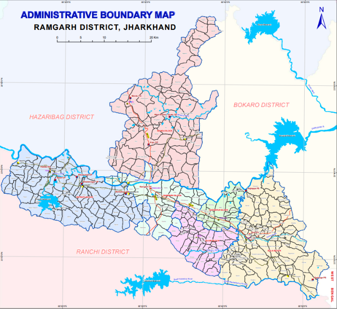
Ramgarh is a district located just 40 Kms from state capital Ranchi in Jharkhand. Ramgarh has a population of 949,443 (52% male, 48% female), with a sex ratio of 921 females per 1000 males and a 73.17% literacy rate. The district has 60% rural population. Key demographics include roughly 23.19% Scheduled Tribes (ST) and 14.20% Scheduled Castes (SC). The major area in the district is either covered by forest or under the coal reserves which puts the district in a major climatic conflict zone due to large scale mining. The major issue at villages is the unavailability of irrigation infrastructure. Irrigation in Ramgarh district, Jharkhand, heavily relies on groundwater (about 58.5% via open wells) and small-scale water bodies, with significant development required for sustainable agricultural growth. Key irrigation sources include tanks, ponds, check dams and wells. Hence there is a dire need to conserve rain water through structural ridge to valley planning.
PRADAN (Professional assistance for development action) started working in the region from 1998 started with collectivizing rural women in SHGs and then subsequently engaged to enhance the income up to 2,50000 INR through various agri allied activities. From last one year i.e. 2025 onwards PRADAN shifted from direct action on the ground to creating an ecosystem to deal with the major challenges of the district. PRADAN plays a crucial role in enhancing livelihood opportunities through agriculture, livestock management, and natural resource management (NRM). It supports farmers in adopting improved agricultural practices, diversifying crops, and increasing productivity, while also promoting sustainable methods aligned with the ridge-to-valley approach. The organization works closely with government initiatives such as NRLM, MGNREGA and other relevant deptt., ensuring effective convergence to maximize benefits for rural households.
Introduction
The experience from Ramgarh district reflects how structured field processes, supported by digital tools and strong administrative backing, can transform the way NRM plans are prepared. With close to 9318 NRM demands collected across around 237 villages, and a vision to scale this across Jharkhand State, PRADAN, with full support from the District Collector, has been able to use the Commons Connect tool to systematically capture, consolidate, and submit village-level needs onto the Yuktadhara portal.
Grounding the Process: Administrative Support and Scale
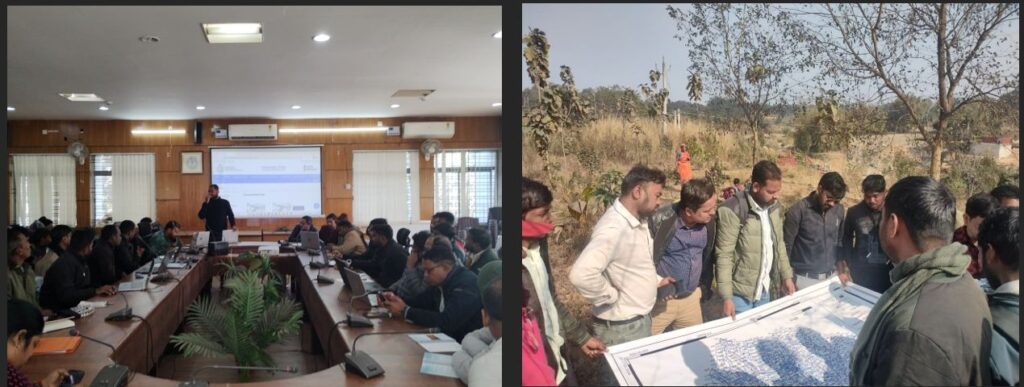
A key enabler in Ramgarh has been the strong push from the district administration. With the District Collector’s active support for digital planning tools, there was clarity and alignment across departments to adopt a structured approach. This made it possible to deploy teams across hundreds of villages, standardize how NRM demands are collected, and ensure that the data generated is usable for planning and submission. The current effort has already covered approximately 237 villages and generated close to 9318 NRM demands, creating a strong foundation for scaling the approach across the entire district.
Field-Level Process: Structured and Time-Bound
At the core of the process is a well-defined field workflow. Teams comprising Rozgar Sewaks, Junior Engineers, SRLM staff, and Panchayat functionaries visited each village and spent approximately two days in each location. During these engagements, discussions were held with community members to identify NRM-related needs, with a focus on practical interventions such as water conservation, land development, and irrigation support. This approach ensured that the demands collected were grounded in lived realities rather than assumptions or secondary interpretations.
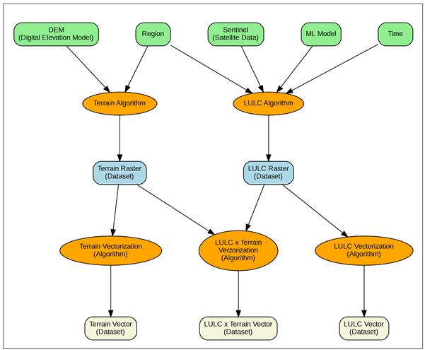
Using Commons Connect for Demand Capture
The Commons Connect tool played a central role during field visits by enabling structured and standardized recording of demands in alignment with the format followed by the Yuktadhara portal. It was used to capture the type of asset or work proposed, beneficiary details including gender, geo tagged location data in the form of latitude and longitude, and key technical parameters such as dimensions.
Demand Analysis: Understanding the Nature of NRM Needs
An analysis of the 9,318 demands collected across 237 villages spanning 6 tehsils of Ramgarh district — Patratu (59 villages), Gola (75 villages), Mandu (43 villages), Dulmi (33 villages), Chitarpur (18 villages), and Ramgarh (10 villages) — reveals important patterns in the nature of community priorities. The dataset reflects a clear distinction between community pool NRM works and individual beneficiary-based interventions, with approximately 629 demands under community works and 8,668 demands under individual beneficiary-based interventions, depending on village context and livelihood needs.
The categorization of demands highlights a strong concentration in specific types of interventions. Plantation and kitchen garden-related works account for approximately 2,817 entries — comprising 420 plantation demands and 2,397 kitchen garden demands — reflecting both ecological restoration priorities and livelihood-linked horticulture and nutrition needs. Livestock and livelihood infrastructure such as cattle shelters, goat shelters, poultry shelters, and piggery units constitute around 3,192 entries, emerging as the single largest demand category and a critical component of rural income diversification strategies, with cattle shelters (1,320), goat shelters (1,020), poultry shelters (392), and piggery units (238) being the primary sub-types. Community pond-related interventions form a distinct category with approximately 13 entries, indicating community interest in shared water bodies as potential aquaculture and livelihood resources.
A particularly significant insight emerges from the analysis of water recharge and irrigation-related demands, which together form one of the most dominant thematic clusters in the dataset. These account for approximately 3,309 entries — including both new infrastructure and repair or maintenance of existing structures — and encompass interventions such as wells, percolation tanks, soakage pits, farm ponds, check dams, trench cum bund networks, contour bunds, and other small irrigation and recharge systems. Within this, wells alone account for approximately 1,143 entries (the single largest water-related sub-type), soakage pits for 556 entries, percolation tanks for 515 entries, the 30-40 model recharge structure for 274 entries, and farm ponds for 49 entries, while check dams account for 18 entries.
The prominence of these water-related demands clearly reflects the centrality of water security in rural planning priorities and highlights the extent to which communities across all tehsils of Ramgarh district are seeking durable water infrastructure solutions to address both agricultural productivity and ecological resilience.
From Village Data to Gram Panchayat level Consolidation, integrating in Yuktadhara portal
While demands were collected at the village level, the Yuktadhara portal requires submission at the GP level. This necessitated a consolidation step in which village-level data extracted from the Commons Connect tool was compiled and organized into CSV files by aggregating demands at the GP level. This process helped bridge field-level data with system-level planning formats, ensuring that information collected from villages could be effectively prepared for upload and integration into the portal.
Following this consolidation, the data was further processed into KML files, which were then uploaded onto the Yuktadhara portal. This ensured that both spatial and attribute-level information were accurately represented within the digital planning system. We are in the process of systematizing this process so that direct CSV exports can be made from CC to upload to Yuktdhara.
What This Approach Enabled & Key learnings:
The Ramgarh experience shows that structured digital workflows can significantly improve both the scale and quality of NRM planning. It enabled the collection of large volumes of demand data across hundreds of villages, ensured consistency in how information was captured, and created clear traceability from village-level demands to district-level submissions. It also strengthened coordination between field teams and administrative systems, supporting a more integrated planning process.
A key foundation of this approach was community consultations conducted before demand collection. Adequate time was spent in each village to ensure discussions were participatory, inclusive, and grounded in actual community priorities rather than predefined assumptions, which strengthened the relevance of the demands captured.
At the same time, digital tools reduced the effort required for recording and organizing data by shifting from paper-based and fragmented systems to a standardized format. This reduced repetitive documentation work and improved efficiency, allowing field teams to focus more on engaging with communities, facilitating discussions, and validating needs on the ground.
The experience also highlights that technology alone is not sufficient; its value depends on how well it is embedded in participatory processes. Structured digital entry reduces administrative burden, while strong coordination between district administration, field teams, technical staff, and community institutions enables smoother execution and more effective planning at scale.
Call for Action:
The Ramgarh experience demonstrates a replicable model for digitally enabled NRM planning that can be scaled across districts and states.
There is a clear opportunity for CSOs and district administrations to jointly strengthen such integrated approaches by investing in interoperability between field systems and government portals, building the digital capacities of frontline workers, and embedding participatory planning as a standard practice. Moving forward, the focus should be on shifting from isolated pilots to wider adoption, where integrated, community-driven planning becomes the norm across geographies.
Special Thanks
We extend our sincere appreciation to PRADAN for its leadership in driving the adoption of Commons Connect in Ramgarh, and to the district administration and field teams for their strong support in enabling large-scale, participatory NRM planning—especially Manas Satapathy, Kanad Ghosh, and Himanshu Nigam for their leadership and on-ground coordination.