Validating Impact: Field Observations from Waterbody Rejuvenation in Madhya Pradesh
Ramneek Kaur, Postdoctoral Fellow, ACT4D group, IIT Delhi
16 February, 2026
Clear skies and a refreshing cool breeze welcomed us as we landed in Khajuraho for a field visit to remote areas in the Chhatarpur district of Madhya Pradesh. Nearly a year has passed since the CoRE Stack team began tracking the impact of waterbody rejuvenation efforts carried out by the A.T.E. Chandra Foundation (ATECF) across India, using remotely-sensed satellite imagery and other secondary data sources. To date, ATECF has rejuvenated 13,720 waterbodies across 13 states and 100+ districts, improving water access for 33,301 villages and over 4 crore people. This three-day visit aimed to validate our methodological choices, indicators, and hypotheses, and to plan the next steps for the Waterbody Impact Monitoring Dashboard being developed by the CoRE Stack team.
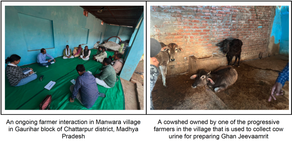
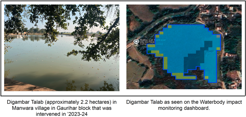
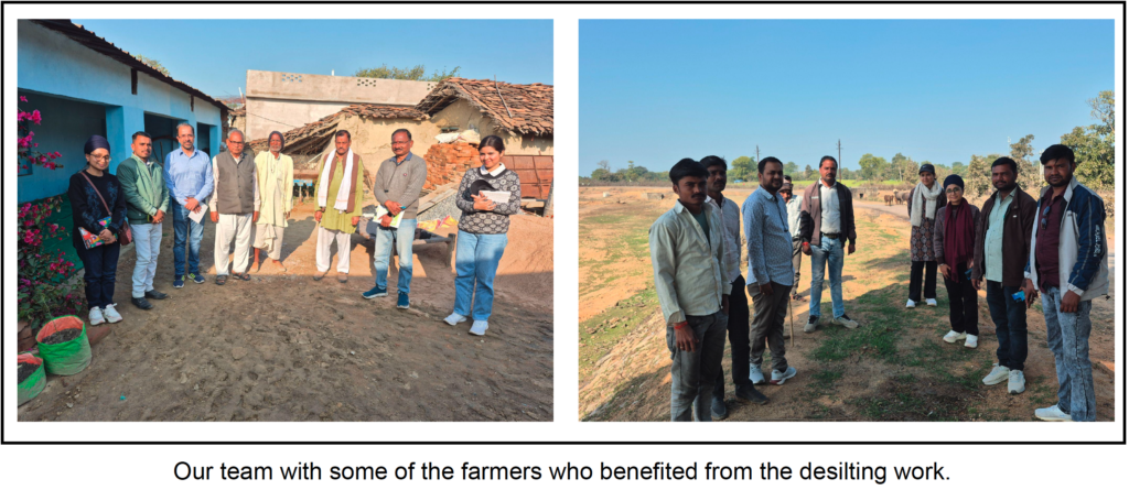
Our itinerary was packed with visits to desilted waterbodies and interactions with farmers who had benefitted from the work, either through applying silt carted to their fields, drawing water for irrigation from rejuvenated waterbodies through pumps or irrigation channels, or engaging in fisheries. The desiltation work for waterbodies in this region was facilitated by the Arunoday Sansthan. The desilting was facilitated under NITI Aayog’s Aspirational Districts Program with local monitoring and community mobilization support from Arunoday Sansthan.
Understanding the Local Agricultural Context
As we drove to Manwara village for our first farmer interactions, bright yellow mustard fields stretched across the landscape. The region falls under the Bundelkhand region, which is known to experience water scarcity due to erratic, insufficient rainfall and a rocky, hard terrain with low infiltration. The region’s lower water availability compared to the upper Gangetic plain shapes distinct cropping patterns: kharif crops include less water-intensive varieties like masur, soybean, sesame, and groundnut, while winter cropping is dominated by wheat, gram, peas, and mustard.
Our conversations with farmers proved invaluable in connecting waterbody rejuvenation impacts to local realities – surface and groundwater availability, cropping patterns, borewell presence, and agricultural practices including natural farming.
Key Impacts Observed
Enhanced Water Availability and Retention
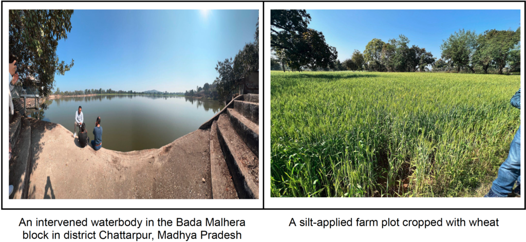
The most pronounced outcome of desilting was increased water availability, both in surface area and temporal retention. Waterbodies that previously dried up by late November now retain water through February. This extended availability has:
- Boosted winter crop yields
- Enabled shifts in cropping patterns, such as from mustard to moong and soybean to wheat
- Benefitted farmers practicing fisheries through sustained water levels
Productivity Gains from Silt Application
Farmers who procured the silt removed from waterbodies reported significant productivity increases. The black soil prevalent in the region makes the excavated silt highly fertile. Silt-treated plots are visibly greener and healthier, with crops clearly distinguishable from those in untreated fields.
A typical desilting operation removes about 10,000 m³ of silt, transported in roughly 3,500 tractor trolleys (about 2.8 m³ each). Farmers may take anywhere from a few to around 200 trolleys, depending on their land and resources. The silt is usually spread over 0.3–0.5 hectares, though this depends on whether the waterbody was deepened, widened, or both.
Current practice suggests that spreading 4–5 inches of silt over one bigha (about 0.29 acres; 1 acre ≈ 3.5 bighas in Madhya Pradesh) requires around 40 trolleys. At this rate, 10,000 m³ of silt can cover about 26 acres (90 bighas), which is a relatively small area. This raises another important question: how often should desilting be done to maximize long-term benefits?
Synergy with Natural Farming Practices
Over the past decade, natural farming has gained momentum in the region, driven by awareness efforts from government agencies, CSOs, and NGOs. Farmers are increasingly using locally prepared inputs such as Jeevaamrit and Ghan Jeevaamrit to improve soil health and manage pests.
Earlier, these inputs were typically supplemented with chemical fertilizers, with farmers applying about 1 quintal (100 kg) each of DAP and urea per acre. After adding nutrient-rich silt to their fields, many farmers reported a significant reduction in chemical fertilizer use. This combination of silt application and natural farming lowers input costs and offers a promising pathway towards more sustainable agriculture.
So far, around 2 lakh farmers have benefited from silt carted under ATECF’s waterbody rejuvenation efforts across India, leading to reduced dependence on chemical fertilizers and significant cost savings.
Challenges in Equitable Access
Despite these positive outcomes, we observed equity concerns in silt procurement. Farmers owning tractor trolleys bore only fuel costs, while others had to rent equipment at ₹200–400 per round, depending on the distance between the waterbody and their farms. This resource constraint affects the equitable distribution of silt among village farmers.
Critical Learnings for Impact Assessment
Our field observations yielded two major insights for refining our impact tracking methodology:
1. The Essential Role of Primary Data
We encountered scenarios where satellite data alone may not capture meaningful impacts. Examples include:
- Reduction in chemical fertilizer use due to silt application
- Nature of excavation (widening versus deepening, or both)
- Increases in fisheries activity
These impacts require ground-level data collection to complement remote sensing.
2. Enhanced Criteria for Prioritization
While satellite data can detect reduced water availability over time, prioritizing waterbodies for rejuvenation would benefit from integrating primary data such as:
- Number of households dependent on the waterbody
- Past impact evidence from similar geographies (productivity increases from silt application, reduction in chemical fertilizer use)
This combination of remote sensing and primary data can provide stronger decision support for targeting rejuvenation efforts where they’ll have the greatest impact.
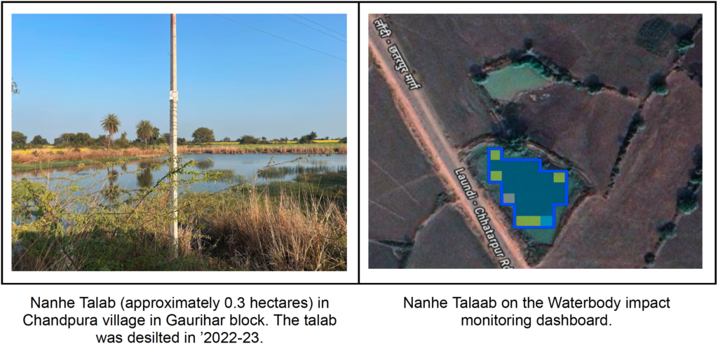
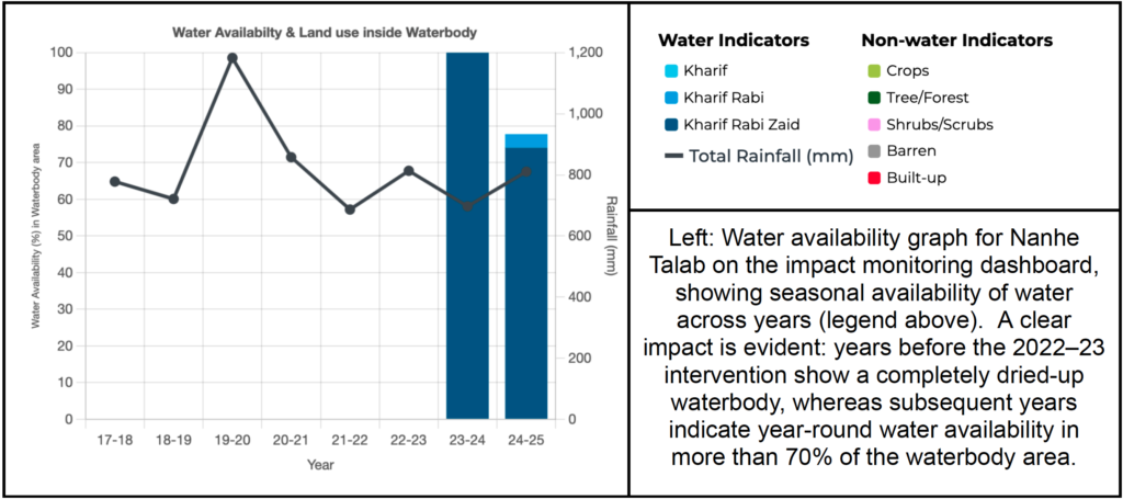
Waterbody Impact Monitoring Dashboard
The CoRE Stack team has developed a Waterbody Impact Monitoring Dashboard to systematically track the impact of rejuvenation efforts implemented at scale. The tool enables mapping of recorded waterbody geocoordinates to remotely-sensed waterbodies, allowing us to visualize individual waterbodies and monitor rejuvenation impacts through metrics such as changes in surface water availability and cropping intensity in surrounding areas. The dashboard also provides hydrological context, including catchment area and drainage network visualization for the corresponding microwatershed, which enables deeper analysis of observed impacts.
The dashboard can support ground-level evaluation of NITI Aayog-supported rejuvenation initiatives in water-stressed regions like Bundelkhand, providing systematic assessment capabilities that complement targeted field validation. This dual approach combining satellite-based monitoring with strategic field verification, allows us to track thousands of interventions while maintaining the contextual understanding necessary for meaningful impact assessment.
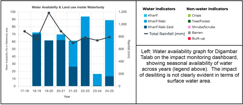
The following visualizations from the dashboard illustrate how waterbody size influences impact visibility. While improvements in smaller waterbodies may be readily apparent through satellite data, the same may not hold true for larger waterbodies. Water availability is influenced by multiple factors such as rainfall patterns, catchment area, inlet channel conditions that modulate rainfall-to-runoff conversion, and water withdrawals – which can mask the direct impact of desilting interventions.
As we develop the impact assessment dashboard, these field insights will be instrumental in creating a more nuanced, context-aware system that captures both the quantifiable and qualitative dimensions of waterbody rejuvenation.