Water security is a critical concern for rural India, particularly as climate change exacerbates water scarcity, impacting both livelihoods and ecosystems. The CoRE Stack’s recently published paper titled “Initial Observations from Field Testing of a Digital Participatory Tool to Improve Water Security in Rural India, to be presented at ICTD 2024 in Kenya, explores an approach to addressing this issue by integrating digital tools with participatory community planning.
This research, conducted across diverse rural regions in India, focuses on the development and deployment of Commons Connect, a digital tool designed to empower local communities in water security planning. By combining geospatial datasets with local knowledge, the tool aims to enable a bottom-up approach to managing water resources, improving both ecological sustainability and equity in resource distribution.
Leveraging MGNREGA for Water Security
The Mahatma Gandhi National Rural Employment Guarantee Act (MGNREGA) has long been a cornerstone of rural development in India. The scheme, designed to provide wage employment through the construction of durable assets, plays a crucial role in building water infrastructure like farm ponds, check-dams, and wells, aimed at improving water security for rural communities.
However, MGNREGA’s effectiveness is often hindered by top-down asset planning, which does not always consider the specific water needs or ecological conditions of local communities. Commons Connect addresses these challenges by integrating local, community-driven demands with scientific planning. By doing so, it ensures that water assets under MGNREGA are both appropriate to the landscape and equitable in their distribution.
Field Locations: Diverse Challenges Across India
Figure 1: The map shows four administrative blocks in different states of India selected for formative research and field testing: Angul block in Angul district of Odisha (with FES), Masalia block in Dumka district of Jharkhand (with SUPPORT, supported under the GIZ ERADA project), Mohanpur block in Gaya district of Bihar (with 4S, supported under the GIZ ERADA project) and Pindwara block in Sirohi district of Rajasthan (with PRADAN, supported under the GIZ ERADA project)
The field testing of Commons Connect was conducted across four distinct regions in India, each with unique water challenges:
- Angul, Odisha: Angul features undulating topography with hills and plains, receiving an average annual rainfall of 1,200 mm. The area rests on an unconsolidated crystalline aquifer. Local farmers, primarily from tribal communities, have shifted their cropping diversity over time due to changes in irrigation methods. Reliance on borewells for irrigation has led to a decline in traditional crops like millets and oilseeds, with current cultivation mainly focused on groundnuts and vegetables. Depth to water in wells has increased to 25-30 feet, as surface water sources are dwindling. Farm ponds and check dams are now constructed to enhance irrigation and groundwater recharge.
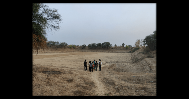
- Masalia, Jharkhand: The Masalia block features a diverse landscape of hills and plateaus with an average rainfall of 1,400 mm. Its hard rock aquifer has limited storage capacity compared to alluvial aquifers. Farmers typically own less than 1 hectare of land, with many landless migrants. The predominant cropping pattern includes rainfed paddy and maize in Kharif, and irrigated vegetables in Rabi, using farm ponds and community water bodies. Borewell use is minimal, but depth to water in wells has increased from 10-12 feet to about 20 feet over the last five years.
- Mohanpur, Bihar: Located in the Indo-Gangetic Plain, Mohanpur experiences an average rainfall of 1,400 mm and has an alluvial aquifer. Farmers mostly have less than 1 hectare of land, and also include significant numbers of landless individuals engaged in tenant farming. The cropping pattern consists of rainfed paddy in Kharif and protective irrigation for mustard and wheat in Rabi through traditional ahar-pyne irrigation systems. However, the increased use of borewells—leading to depth to water in wells of more than 120-300 feet—has contributed to the neglect of these traditional irrigation methods.
- Pindwara, Rajasthan: Pindwara is situated in the rocky terrain of the Aravali hills, with an annual rainfall of 600-800 mm and a hard rock aquifer with low recharge capacity. Farmers from various caste groups cultivate maize in Kharif, and mustard, wheat, and vegetables in Rabi, often leaving fields fallow in the summers. Irrigation relies on traditional structures like nadis, check dams, and borewells. However, siltation has reduced the storage capacity of many water structures, increasing dependence on borewells, which have had to be deepened to more than 70 feet.
Issues Found During Formative Research
The formative research revealed several critical issues that hinder effective water security planning:
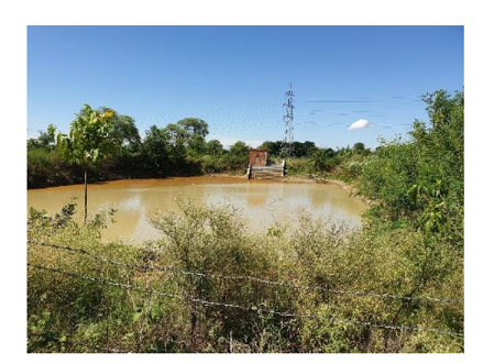
- Unscientific Site Selection Leading to Asset Failure: In many regions, water assets such as check-dams and farm ponds were poorly located, resulting in inefficient water storage and groundwater recharge. For example, in Pindwara, we found a check-dam constructed too high along a drainage line, while wells in Angul were built in groundwater discharge zones and led to delayed irrigation due to a longer time taken for the wells to gain water, limiting the availability of groundwater during irrigation periods.
- Social Inequities in Resource Allocation: The formative research also highlighted the unequal distribution of water assets, particularly for marginalized communities. In Mohanpur, for example, water resources were often allocated to wealthier groups, while marginalized communities were left without adequate access to irrigation infrastructure.
- Limited Ecological Awareness and Data Literacy: Communities were aware of local water challenges but lacked a shared understanding of long-term ecological impacts. In Mohanpur, farmers continued to dig deeper borewells despite obvious groundwater depletion and stress. Furthermore, low data literacy made it difficult for many communities to interpret complex ecological data, limiting their ability to participate in water planning discussions effectively.
How Commons Connect Aims to Address These Issues
While this is just the first version of Commons Connect and has many gaps, our goal is to improve the work to address some of these key issues:
- Data-Driven Site Selection: By integrating geospatial data, Commons Connect ensures that water assets are placed where they will be most effective. The tool helps users identify optimal locations for water retention structures, such as check-dams and ponds, based on a scientific analysis of terrain and water flow, addressing the issue of poorly placed assets.
- Promoting Equity in Resource Distribution: The tool incorporates resource mapping, tracking asset ownership and usage to expose inequalities in resource allocation. This transparency helps ensure that future water assets are distributed more equitably, benefiting marginalized communities who were previously overlooked.
- Building Ecological Awareness and Data Literacy: Commons Connect provides simple visualizations and automated text descriptions of key ecological indicators, such as rainfall patterns and groundwater levels. This helps communities build a shared understanding of local water challenges and encourages collective action, such as limiting the construction of borewells or adopting sustainable cropping practices. Training modules for field staff and community volunteers also help bridge the data literacy gap, enabling more meaningful participation in water planning.
Figure 2: The figure shows Commons Connect screenshots for the Groundwater and Waterbodies screens. Change in groundwater levels are shown for each micro-watershed (first, from left to right), and helps identify which areas have greater groundwater stress than others, to encourage communities to reflect and compare different geographies. Fortnightly time series of precipitation, runoff, evapotranspiration, and groundwater change can be analysed upon selecting a microwatershed (second, from left to right), and can be used to describe to communities how changing rainfall patterns and cropping patterns can exacerbate groundwater stress. Presence of surface water in Kharif, Rabi, and Zaid can be analysed (fourth, from left to right) for each water body upon selecting a surface water body detected through remote sensing (third), and identify which waterbodies may benefit from de-silting or repairs, which ones may be suitable for fishery, the availability of water for livestock, and other such water-dependent livelihood.
Figure 3: The figure shows Commons Connect screenshots for the Agriculture screen (first, from left to right) with cropping intensity classification across the years, helpful to highlight inequalities in access to water for irrigation which might be contributing to some areas being regularly double or triple cropped, alongside areas which are single cropped. The percentage of weeks under mild, moderate, and severe drought for each year can be analysed upon selecting a microwatershed (second), to understand drought incidence frequency. Similarly, uncropped area and area under single, double, and triple cropping can be analysed for each year (third), to highlight the impact of drought on cropping intensity.
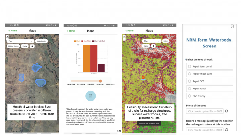
Figure 4: The figure shows Commons Connect screenshots with the recharge potential layer (first, from left to right) to identify areas of good, moderate, and low recharge, built using the CLART algorithm (CLART has been developed by our partner, FES), and improve the likelihood of proposing structures in good locations. Community members along with CSO staff and community volunteers can propose new structures on the tool by providing relevant specifications such as the type of work (second, from left to right) and essential dimensions, to eventually generate a proposed plan for the area in an appropriate format such the as Detailed Project Report (DPR) for its submission at the Gram Sabha and eventual approval at the panchayat level, followed by fund allocation at the block level (third, from left to right).
Figure 5: The figure shows sequential steps for a resource mapping exercise on the Commons Connect tool. This starts by adding/geotagging (as shown by red marker on the map) a settlement (first, from left to right) on the tool. Corresponding wells (second) and waterbodies (third) owned/used by this settlement can then be added. Coarse land ownership can also be indicated by selecting sample grids of land owned by the settlement (fourth). Metadata of the settlements, wells, waterbodies, and crop grids is also collected. These maps can be used to highlight inequities in access to assets and make arguments for proportionate allocation of future funds for communities that have not received these assets so far.
Building a Sustainable Future with MGNREGA
MGNREGA remains a vital framework for rural water infrastructure development. By incorporating Commons Connect into MGNREGA’s asset planning process, communities can now take an active role in decision-making, ensuring that water structures are scientifically planned and distributed equitably. The tool generates Detailed Project Reports (DPRs) for proposed water assets, which can be directly integrated into MGNREGA’s administrative workflow for faster approval and implementation. The combination of community-driven demands, supported by scientific data, can significantly improve the effectiveness of MGNREGA projects, leading to more resilient water systems that meet the real needs of rural India.
Acknowledgments
None of this would have been possible without valuable insights and field support from our partners. A very special thanks to Subrata Singh, Chiranjit Guha, Yogesh Barola, Himani Sharma, Mahesh Jadav, Pratiti Priyadarshini and the wider FES team, for their constant support, encouragement, and thought partnership. Our sincere gratitude to the teams at SUPPORT in Dumka, 4S in Gaya, PRADAN in Sirohi, Jan Jagran Kendra in Giridih, CCD in Adilabad, SPWD and JJBA in Latehar, and IIT-IIT in Kolar, for field access. Finally, our heartfelt thanks to our donors: GIZ, Common Ground, Rainmatter Foundation, Tower Research, Hellermann Tyton and Tarides whose generous contributions have enabled us to build the CoRE stack so far. We would also like to especially acknowledge Sharat Singh from GIZ for believing in our vision and being the first one to mobilize support for the CoRE stack.

