Across rural India, communities depend on common lands, water resources, forests, and grazing areas for their livelihoods. Community representatives, also known as landscape stewards, are often deployed in many areas to mobilize community members into collective decision making on managing their commons. As mandates for data driven natural resource management take ground, these stewards are increasingly pushed into labor linked with data collection and reporting, with little to no investment in upskilling them to understand, analyse, and challenge data that doesn’t serve equity and commoning goals.
Commons Connect, a digital job aid built exclusively for landscape stewards, helps them mitigate these exact issues. The platform integrates geospatial data with community-owned information, allowing local stewards and civil society organizations to create village-level natural resource management plans that are both evidence-based and grounded in community priorities. Trusted by over 20 civil society organizations with operations across 9 states and 90 tehsils in India, Commons Connect powers the stewardship efforts of over 430 community representatives. In this blog, we unpack the voices of these stewards as they share their experiences with Commons Connect.
From data collection to sense-making
One of the most significant benefits reported by stewards is the reduction in time required for planning. Digital Detailed Project Reports (DPRs) are generated on the fly by combining information from community consultations, proposed demands, and geospatial analytics. As a result, stewards report a 70% reduction in the time spent creating DPRs.
For frontline workers, this means more time can be invested in engaging with communities rather than compiling datasets. Tankadhar, a team lead at Seba Jagat in Odisha puts it succinctly,
“I have been associated with Seba Jagat for the past 18 years and have therefore been involved in overseeing NRM planning in the villages for a long time. It would take us weeks to prepare a plan for a single village with the pen and paper method and often, we wouldn’t have any common detailed project report document that the community and government authorities could refer to at any time. With Commons Connect, the entire process of PRA and demand collation takes about just five days for a village, leaving the CRPs with more time to spend in community consultations. Moreover, there is a single plan document for everyone’s reference and follow-ups now.”
Similarly, Sanjay, a lead Community Resource Person (CRP) with Utthan in Gujarat shares,
“With Commons Connect, we spend more time mobilizing the community, analyzing problems, and discussing solutions. The time to create DPRs reduces drastically and we do not have to spend time on tasks of collating different geospatial datasets”

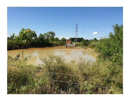
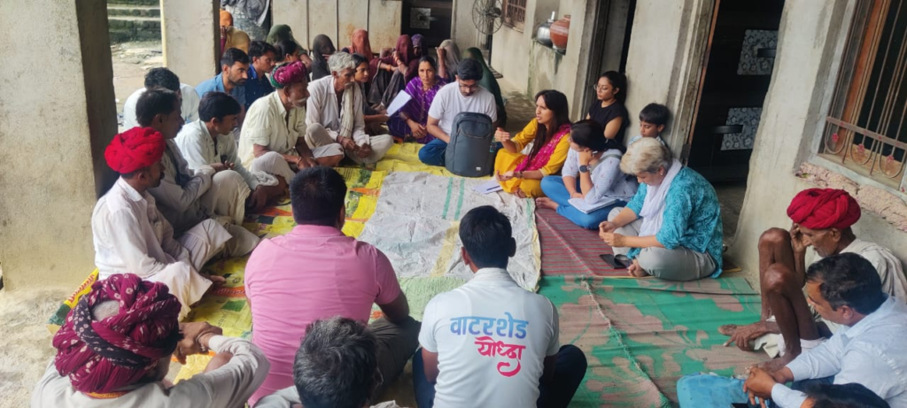
Field testing of Commons Connect in Bhavnagar, Gujarat with Sanjay (Lead Steward) and his team. Take a look at the complete journey of piloting Commons Connect for natural resource management by Utthan in Gujarat.
At the time of writing this blog, 327 DPRs have been submitted for approvals, of which demands from 100 DPRs have been approved by the Gram Sabha.
Giving a data driven voice to marginalized communities
Beyond efficiency, Commons Connect is helping bring equity considerations into planning processes. By documenting caste-based access to water assets, land, and livestock, the platform encourages that resource allocation decisions account for social inequities from the outset. According to our impact assessment, 40% of stewards reported factoring equity considerations into planning, while 60% of organizations observed increased participation of women.
The value of this approach is evident on the ground.
“The data speaks for vulnerable caste communities. We have noted members from tribal communities being able to voice up their opinions once the data advocates for them. In one of the villages, it became evident that 5 households of migrants did not have access to clean drinking water while the other 15 households who owned land, had adequate structures. The equity perspective brought in by Commons Connect allows the community to prioritize community assets over private ones,” explains Dron, Project Manager at FES, Odisha.
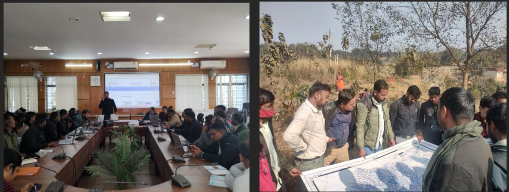
Workshop hosted by FES in Rajasthan to discuss Commons Connect scale up. Here are some insights from the workshop
Sanjeev, a block catalyst with Abhivyakti Foundation in Jharkhand, also highlights: “The data collected during transect walks is extremely valuable. We understand the state of existing water structures, the nature of landholding and socio-economic marginalization within a village, area under cropping and the kind of crops grown. This data, when automatically converted into a detailed project report, helps us advocate for community demands at gram sabha. I recently presented a DPR for a panchayat to the block development officer, who was appreciative of the efforts and recommended following the same approach for NRM planning in other panchayats.”
Across organizations, stewards have reported the difficulty in surfacing tensions around caste hierarchies and inequitable resource allocation without evidence that can be trusted by the community. When data around resource access gets documented collectively by the community and is visualized on the app in real time, it helps them identify social groups with little to no private asset ownership and propose public assets for them.
Building evidence for community demands
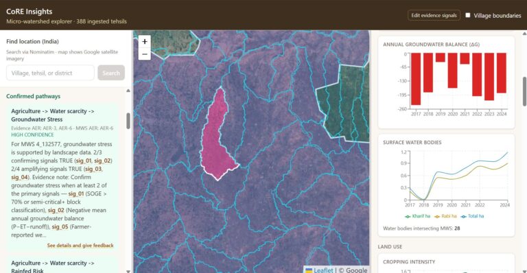
Commons Connect also helps communities understand complex environmental challenges through visualizations of landscape patterns such as groundwater stress, poor irrigation support, and drought resilience. These insights support informed discussions about long-term resource sustainability and intervention planning.
Kanad Ghosh, team coordinator from PRADAN in Jharkhand shares that data shown on the app helps in mobilizing communities towards more effective interventions.
“Earlier, the community members would demand a dug well at a place without accounting for its feasibility. Through the use of the CLART layer, the app clearly shows whether or not an area is suitable for a recharge or harvesting structure, thereby making site suitability of an asset easier to communicate to the community.”
PRADAN piloted Commons Connect use across Ramgarh district in Jharkhand, championing the integration of the tool with government’s GIS enabled portal Yuktdhara. PRADAN’s journey with Commons Connect is documented here.
Ajmal, a lead CRP at SUPPORT in Jharkhand, also highlights this benefit: “With the help of Commons Connect, we are able to visualize groundwater stress and mobilize the community to think of sustainable solutions. Moreover, the site-specific layers such as CLART and drainage lines guide us towards suitable sites for interventions.”
Importantly, the platform is also influencing how organizations approach planning. Two-thirds of stewards report an increase in data-informed decision-making, while 40% of organizations have observed a shift towards community-driven demands.
Commons Connect is being adopted in 1460 villages. Of these, natural resource management plans have been created in 480 villages and taken to Gram Sabha for approvals in 327 of those. Together, the submitted plans make up for close to 9000 demands for soil and water conservation assets and livelihoods support.
Commons Connect demonstrates how technology can strengthen landscape stewardship across rural India when it amplifies local knowledge rather than replacing it. By combining geospatial science with community realities, it is helping rural communities prioritize and manage their natural resources more effectively and equitably.